Knowing that usually, in the High peak of Derbyshire, there is more snow than on the lower ground, we got booted up and ready to walk the whole day in what promised to be a winter wonderland. However, the further North we went, the less snow we saw. Were we disappointed? Well, take a look at the view that greeted us. Would you have been?
No - us neither!

Don't forget, you can see a larger version of any of the pictures by left clicking on it with your mouse. If you want to save the picture to your computer, right click on it and select 'save picture'.
We decided to park at Fairholmes visitors centre, at the side of Ladybower reservoir. Our route was then over the top of Hagg side to Lockerbrook farm, then onward and upward to Alport castles, the largest natural landslip in Europe.
 The morning sun lit the reservoirs to a shimmering expanse and it was beautiful. Despite the lack of snow, today gave promise in lots of other ways. The light was particularly good for photography. The walk up through the woods made us feel good to be alive!
 I paused to look up - this is what I saw.
The pines reaching for the warmth of the sky.
 At the top of the woods, this small gate leads out onto the hillside and we were greeted by the fabulous blue hues of our winter sky, tinged with just a sprinkling of snow.
 We turned left, and got our breath back along the flat track with views forward to the Southern edge of Kinder Scout. That hunch you see on the horizon is Back Tor on the Lose hill to Mam tor ridge. You can always pick out its distinctive shape.
 Here's Sue, ready for the day, with Woodlands valley behind her.
 We walked along the edge with only the odd sheep for company.
 The business part of the walk!
  Looking back along the edge.
 After the Castles, we turned sharp right and dropped steeply back down towards a finger of Howden reservoir, but we then turned left again at the bottom, and started the long climb up onto Cronksley moor. The day was still really clear and living up to the mornings promise. It was cold, but perfect for walking. We saw lots of impressive icicles hanging from the peat.
 Here's a happy lad!
 Our goal for lunch - our favourite shooting cabin, where we had lunch. Surprisingly, there were two other couples there and we spent lunchtime in pleasant conversation.
 The road onwards was a dream come true, with inviting views of Derwent edge. Although the days were now drawing out, we'd neither the time, nor the light, to visit the edge, which would have added maybe 2 hours to our route (which was already 7 hours long).
 We dropped off the moors to meet the young river Derwent. We forded this (and I got a boot full of VERY cold water), and then followed it as it wound down the valley towards captivation in the reservoirs. Here I am at the bottom of Cranberry clough, posing on a small footbridge.
 This is Slippery stones bridge. When the reservoir chain was flooded, it would have been submerged, but it was disassembled and re-built at the head of the valley, where it now stands today.
 Sue sits and reflects on a perfect day.
  A tranquil scene.
 A small puff of cloud lends itself to a photo.
 I can't remember us having had a lot of rain recently, but the reservoir chain was full to capacity and the water was flowing over the top of the Howden dam.
 Looking back to Howden dam, the sun just catching the Eastern tower.
 A zoomed shot onto Derwent edge, and one of the many weathered rock formations.
 We got back to the car about 5:30PM. It really had been so perfect today that we were sad it was over. We'd walked 15.6 miles, and taken in almost 3,000 feet of ascent. This was our last view of the reservoir before climbing into the car and wending our way home. Beneath this picture are a couple of short videos, the first time I've put any on blogger.
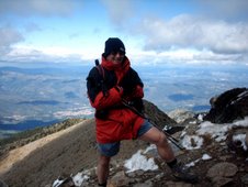
 Here I am near the shooting cabin, showing you the panorama over Derwent edge.