At LAST, we got a really good forecast for our Tuesday walk, and so decided to do a big-ish one. It started out as a nine-miler, but due to Sue's excitement and; 'lets do THAT as well' mentality, it turned into just over ten miles and just over 2,000 feet of ascent!
This is the view we got as we topped Winnats pass. Rushup edge was to our right and we were hopeful that this type of 'clearing cloud' would be the order of the day.
This is the view we got as we topped Winnats pass. Rushup edge was to our right and we were hopeful that this type of 'clearing cloud' would be the order of the day.
 Looking back was better, this is the view along the Mam Tor ridge to Lose hill.
 However, we also saw this HUGE bank of clouds, just rolling across the hills.
 The forecast was for a cloudy start, improving as the day went on. The trouble with Kinder Scout, where we were heading, was it didn't often pay attention to the weather man, and sort of just did what it wanted.
We reached Bowden Bridge, and looked forward and up to Kinder. Oh dear, COVERED in heavy cloud and mist, This did NOT bode well.

Those skies look a bit black too. Would we get a soaking? It looked that way.

 Ever the optimists, Sue, Tom and I set off for the wild, grey yonder, hoping it would turn into the wild BLUE yonder.
Looking ahead, we didn't think there was much chance of THAT!
 Well, well, what do you know? As we climbed, the sun grappled it's way through and started to burn off the mist, leaving us warm, and with the sort of views we'd hoped for. The stiff climb up William clough had us sweating, and soon we were down to tee shirts - in late NOVEMBER.
 The recent rains made for some nice little waterfalls.
 Here's Sue & Tom, pressing onward and upward.

 Due to erosion, as on so may paths in the Peak district, the final few metres are slabbed. It's not the prettiest of things, but I agree with it as something is needed, and this seems one of the most sympathetic ways to tackle the problem.
 This was the view North to Saddleworth moor.
 Kinder reservoir.
 Here I am, having topped out. The view back is STILL a bit angry looking, but so far NO rain.......YET.
 The path around Kinder edge.
The sheep seemed totally unconcerned with it all.
 The cliffs around the edge make a great viewpoint back.
 After a walk around the edge of Kinder Scout, we approached the downfall (a waterfall). This place used to attract ice climbers in winter when it froze as a solid wall of ice. We seldom get those sort of winters now, and I have yet to see this 'wall of ice' I've heard about and seen pictures of. There had been a lot of rain recently, and we expected a bigger flow, but this is about par for this waterfall, and I've seen it in this state many times.
 Rocks on the edge, and view back to Kinder reservoir
 Looking over the lip of Kinder Downfall.
 How WILL we cross this 'raging torrent'? :-)
 The water from the moor is VERY brown and 'peaty' (surprise, surprise).
 This is the view looking back to Kinder downfall from Sandy Heys.
The falls are in the nick to the right, so you can't see them.
 Looking South.
 The wind does strange things to the rocks up on Kinder, this one looked at though it was balanced on three points.

 Some wind sculptures.
 Who does this rock look like when turned on its side?
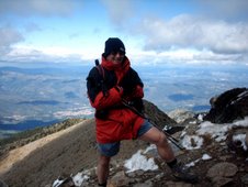
 We eventually reached the trig' point at Kinder Low ('low' meaning 'high' in Derbyshire), and set the timer for the 'team picture'. The cool wind had made us put our coats back on.
 We could see Mam Tor in the distance now, and very nice it looked too.

 This is where Sue had her; 'lets do THAT', moment. This is South head, and Mount Famine in the blue (yes, it had turned) yonder. Our path lay to the right here, past Edale cross, but Sue had other plans. Although it was getting a little late, we figured we'd got time to take them both in, and still have time to get back before dark.
So, off we set.
 We hadn't really figured on the extremely boggy conditions, and spent a lot of time trying to negotiate the thick, oozing peat.
 The cliffs around the edge make a great viewpoint back.
 After a walk around the edge of Kinder Scout, we approached the downfall (a waterfall). This place used to attract ice climbers in winter when it froze as a solid wall of ice. We seldom get those sort of winters now, and I have yet to see this 'wall of ice' I've heard about and seen pictures of. There had been a lot of rain recently, and we expected a bigger flow, but this is about par for this waterfall, and I've seen it in this state many times.
 Rocks on the edge, and view back to Kinder reservoir
 Looking over the lip of Kinder Downfall.
 How WILL we cross this 'raging torrent'? :-)
 The water from the moor is VERY brown and 'peaty' (surprise, surprise).
 This is the view looking back to Kinder downfall from Sandy Heys.
The falls are in the nick to the right, so you can't see them.
 Looking South.
 The wind does strange things to the rocks up on Kinder, this one looked at though it was balanced on three points.
 Some wind sculptures.
 Who does this rock look like when turned on its side?
 We eventually reached the trig' point at Kinder Low ('low' meaning 'high' in Derbyshire), and set the timer for the 'team picture'. The cool wind had made us put our coats back on.
 We could see Mam Tor in the distance now, and very nice it looked too.
 This is where Sue had her; 'lets do THAT', moment. This is South head, and Mount Famine in the blue (yes, it had turned) yonder. Our path lay to the right here, past Edale cross, but Sue had other plans. Although it was getting a little late, we figured we'd got time to take them both in, and still have time to get back before dark.
So, off we set.
 We hadn't really figured on the extremely boggy conditions, and spent a lot of time trying to negotiate the thick, oozing peat.
It slowed us down for a while, but things improved when we got onto the hills.
 A look to our right revealed this horrendous sky over Kinder, where we'd just come from. How on EARTH were we to stay dry with THAT lot looming???
 Only one thing to do - press on, and we reached the summit of South head in no time at all.
This is the summit cairn of rocks.
 South head - done! All that was left was to walk over Mount Famine.
 What a lovely end to the day. As we did the final climb over Mount Famine, we were treated to a lovely sunset.

 We reached the valley floor again, and in the dying light of the day, I took this picture of a weir.
We all went for a well-earned pint in the 'Sportsman' pub and congratulated ourselves on a terrific walk (and not ONE spot of rain all day).

 A look to our right revealed this horrendous sky over Kinder, where we'd just come from. How on EARTH were we to stay dry with THAT lot looming???
 Only one thing to do - press on, and we reached the summit of South head in no time at all.
This is the summit cairn of rocks.
 South head - done! All that was left was to walk over Mount Famine.
 What a lovely end to the day. As we did the final climb over Mount Famine, we were treated to a lovely sunset.
 We reached the valley floor again, and in the dying light of the day, I took this picture of a weir.
We all went for a well-earned pint in the 'Sportsman' pub and congratulated ourselves on a terrific walk (and not ONE spot of rain all day).