Although running low on stock after a very busy period in the cafe we run in Bakewell, we decided that we MUST walk on Tuesday. Sue asked if we could go up onto Kinder Scout. For those of you that don't know, this is NOT a benevolent young lad in a uniform, but Derbyshire's highest point. Not a mountain in the accepted 'pointy' form, but a high plateau consisting mainly of peat - yes, the stuff you put on your garden! It can be a dangerous place in bad conditions (it has it's own mountain rescue service to prove the point), but today it was as benign and beautiful as I've ever seen it. We set off after parking the car on the A57 Snake pass, a winding road that runs between Manchester and Sheffield, to the sounds of skylarks and curlews. Oh what a delight this day was already. The streams down from the moor were looking quite healthy too after recent rains, so we had plenty of bubbling, dancing water sounds to accompany us on the climb up. So, we booted up, and got ourselves ready for the ascent up to 1,000 feet.
Don't forget, if you left click on any of the pictures, you'll get a larger version of it.
(Just click on 'back' to return to the blog afterwards)
 This was where we were going - the Northern edge of Kinder Scout.
On day like today, where else in the world could be nicer?
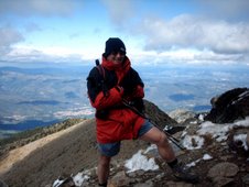
 Just time for a quick self-timer........
 Before the serious stuff began.....
 As I said, the streams were lively, and we saw a few nice waterfalls (VERY inviting on a warm day like today).
 This is the lower approach to Blackden brook, so sheltered that even the May blossom was new here. In most places it had died off by now, but the height, coolness & lack of sunshine here stunts it.
Even Sue couldn't resist the water.
 But the hard climb took its toll, and we had a rest stop.
WHAT a backdrop though.
 As Sue said, when you sit and take the time to look (we quoted that 'what is this life, but full of care, we have no time to stand and stare' poem), you see all sorts. We spotted this very well camouflaged moth on a rock. Can you see it, centre picture?
(Left click to enlarge the picture)
 The final push to the top - was all that hard work worth it......?
 You tell ME.........
 By the look on Sue's face, I have my answer.
 Mind you, it DOES take it out of you a bit, so a lunch stop was now in order.
Sue.....SUE!.......are you awake???
 If you can't beat 'em.........
 Even in this inhospitable place, there's beauty. Bog cotton grows in huge patches, and seems to love the arid and acidic peaty conditions.

 The wind up here can tear lumps out of you, I've BEEN up here when it's difficult to stand up. Not today though, today was just perfect, with a very light, cooling breeze on us.
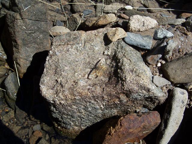
Look at any of the rocks though, and you can see the weathering effect the wind and blown grit has on them.

 The final push to the top - was all that hard work worth it......?
 You tell ME.........
 By the look on Sue's face, I have my answer.
 Mind you, it DOES take it out of you a bit, so a lunch stop was now in order.
Sue.....SUE!.......are you awake???
 If you can't beat 'em.........
 Even in this inhospitable place, there's beauty. Bog cotton grows in huge patches, and seems to love the arid and acidic peaty conditions.
 The wind up here can tear lumps out of you, I've BEEN up here when it's difficult to stand up. Not today though, today was just perfect, with a very light, cooling breeze on us.
Look at any of the rocks though, and you can see the weathering effect the wind and blown grit has on them.

The peat also suffers from the same thing, plus feet tend to wear it away quite badly.
 The view from the edge to the Alport valley

At last we reach the turning point, Crookstone knoll. The path here does a 90 degree right, and heads West, towards Edale. The views all around from this point are stunning. This is Ladybower reservoir, Bamford and Stanage edges, plus Win hill.
 As the path turns, you get the full view of the Mam Tor to Lose hill ridge. This is a zoomed shot of the footpath up Mam Tor. This local beauty spot is a victim of its own accessibility, and there's a LOT of erosion on it.
 Now we had to get down off the plateau.
 The view from the edge to the Alport valley
At last we reach the turning point, Crookstone knoll. The path here does a 90 degree right, and heads West, towards Edale. The views all around from this point are stunning. This is Ladybower reservoir, Bamford and Stanage edges, plus Win hill.
 As the path turns, you get the full view of the Mam Tor to Lose hill ridge. This is a zoomed shot of the footpath up Mam Tor. This local beauty spot is a victim of its own accessibility, and there's a LOT of erosion on it.
 Now we had to get down off the plateau.
 We decided on Ollerbrook clough, a steep but 'fun' way down!
 It soon evened out though, and the decent became more relaxed. We hadn't seen another person for HOURS at this point, we had the whole world to ourselves.
 No sooner had we reached the bottom of the clough, than the scenery changed.
We now had the verdant meadows and holiday cottages. A pretty variation to what we'd had on the top of Kinder.

 .....and, as usual, the bees were taking advantage of the blossom on this warm day.
 Lose hill, from the Edale valley path
 ...and Back Tor, it's face looking remarkably like a smaller version of the Southern face of Mam Tor. The limestone and gritstone of the Peak District meet at this point, so the whole ridge is relatively unstable, and there have been many landslips in the past. You can see the evidence of this one below the face, if you look carefully.

 We then turned west again, and along the Roman road towards the car. This is looking back from the road.
One trial remained though.
 We decided to try and pathfind the final couple of kilometres along the banks of the river, as the only alternative was to walk along the Snake road. I didn't fancy this, so I had poor Susie wading the river Ashop a couple of times before we finally got back to the car at 6:30PM. She forgave me later though, when I cooked her a nice Thai prawn curry!
 A couple of videos from the walk;
 It soon evened out though, and the decent became more relaxed. We hadn't seen another person for HOURS at this point, we had the whole world to ourselves.
 No sooner had we reached the bottom of the clough, than the scenery changed.
We now had the verdant meadows and holiday cottages. A pretty variation to what we'd had on the top of Kinder.

Rhododendron lined the route now.........
 .....and, as usual, the bees were taking advantage of the blossom on this warm day.
 Lose hill, from the Edale valley path
 ...and Back Tor, it's face looking remarkably like a smaller version of the Southern face of Mam Tor. The limestone and gritstone of the Peak District meet at this point, so the whole ridge is relatively unstable, and there have been many landslips in the past. You can see the evidence of this one below the face, if you look carefully.
People often talk about the 'pearly gates', and I wonder if this would be MY version, if I went to heaven?
 We then turned west again, and along the Roman road towards the car. This is looking back from the road.
One trial remained though.
 We decided to try and pathfind the final couple of kilometres along the banks of the river, as the only alternative was to walk along the Snake road. I didn't fancy this, so I had poor Susie wading the river Ashop a couple of times before we finally got back to the car at 6:30PM. She forgave me later though, when I cooked her a nice Thai prawn curry!
 A couple of videos from the walk;
The fantastic view as you top out Blackden brook on Kinder's Northern edge.
A cooling face wash in a Blackden waterfall.
NEXT POST
CLICK HERE

No comments:
Post a Comment